Infrasense was tasked with carrying out a subsurface utility engineering (SUE) survey within the vicinity of three culvert alignments located in the mountains of New Hampshire. This survey involved completion of both electromagnetic induction (EMI) and 3D ground penetrating radar (3DGPR) data collection. Results of the geophysical data collection were analyzed to interpret and create maps identifying locations and conditions of individual utilities, as well as any subsurface obstructions within the survey area.
COOS COUNTY, N.H., Feb. 26, 2025 /PRNewswire/ — A subsurface utility engineering (SUE) survey was recently completed by Infrasense engineers along ski slopes in the mountains of New Hampshire. A combination of electromagnetic induction (EMI) and ground penetrating radar (GPR) methods were utilized during this survey to designate the locations, depths, and service type of utilities. Various utility surface features were also located in the field including transformers, utility poles, and catch basins. Both the EMI and GPR surveys were completed in one day, using a side-by-side setup of vehicle-facilitated GPR data collection. The survey area included a diverse makeup of terrain, including gravel road, landscaped, grassy, and open areas. Each utility identified during the collection was recorded using RTK GPS and field notation and identified on the ground surface with marking paint, and the various site conditions allowed for depth penetration across the site to approximately 12 feet.
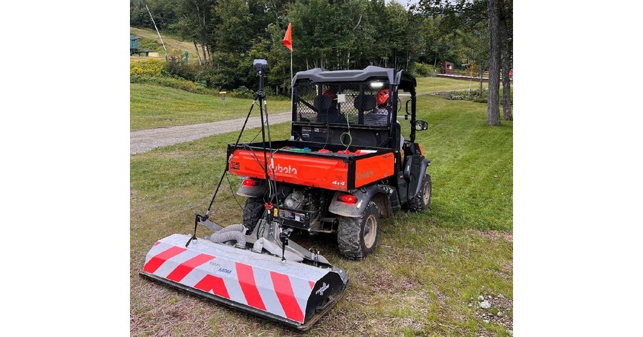
Photo of 3DGPR setup used by the Infrasense team.
The Infrasense field team carried out the EMI testing using a Dynatel 2573M and/or Subsite Electronics 750 R/T EMI tool to locate and trace utilities that were accessible from utility poles, electrical transformers, snow making guns, etc. The active mode on the EMI tool facilitated the placement of a signal on a ferrous utility or metal “snake” at various frequencies. These frequencies are picked up by a handheld receiver, which allows for tracing of its path. On the other hand, passive mode focuses on active AC power transmitted through a utility, from which 50/60 Hz frequencies are received and buried electrically charged lines can be traced. During this survey, the EMI tool was used in active mode to apply a traceable signal onto each of the identified corrugated pipes and subsequently tracked along the alignments.
The GPR survey was conducted using an 8-channel pushcart GPR system that employs up to 18 GPR antennas with a center frequency of 450-MHz. This allows for a typical depth of penetration of 10-12 feet under favorable subsurface conditions. In this case, the depth penetration across the site was approximately 12 feet. The side-by-side collection setup integrated the antennas and electronic distance measuring instrument (DMI), while streaming RTK GPS. Data was collected using overlapping traverses at a rate of 20 scans per foot. The GPR data confirmed the position of pipes and provided a better depth estimate for all areas where the pipes were detected up to 12 feet below the surface.
The three targeted culverts were mapped with a combination of the EMI and GPR method data, along with any other identified site utilities. These maps were produced by interpretations made using the processed EMI mapping and GPR data and were then overlaid on the site base-map. The GPR utility results were compared to the EMI and as-built information to confirm the service type when possible, and to avoid double reporting of the same service lines.
About Infrasense, Inc.
Since 1987, Infrasense, Inc. has applied advanced technologies to address the most difficult challenges in subsurface scanning. Infrasense’s engineers nondestructively extract critical information from a diverse range of structures. In addition to providing ongoing subsurface evaluation services to clients across the country, the firm has also conducted numerous research programs to advance the field of subsurface detection and nondestructive evaluation. To learn more about Infrasense and the services we provide, visit our website: http://www.infrasense.com.
SOURCE Infrasense, Inc.
